

Triangulation Exercise
Another Triangulation Exercise
If you came directly to this page from some other site, you should start on the home page or at least read the Triangulation Page first.
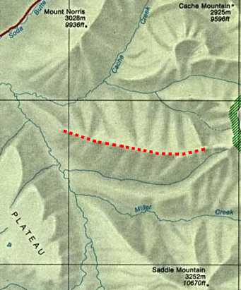
You have just climbed the highlighted ridge after fishing in Miller Creek. You do not know where along the ridge you are standing, but you can see 3 mountains off in the distance north and south.
You take bearings to the mountains and get:
- 333 degrees to Mt. Norris
- 33 degrees to Cache Mountain
- 161 degrees to Saddle Mountain
To simulate taking each of these bearings, turn your compass dial until that bearing is at the index pointer. Then, turn the compass until RED is in the Shed and the direction-of-travel arrow will be pointing along that bearing.
Transfer your bearings to the map and find out where they intersect. If you oriented your map, took correct bearings, and transferred them accurately, your map should look close to:
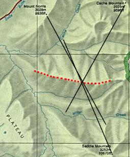
Notice that two bearings that are nearly opposite each other do not do a good job of triangulating. It is important to get another landmark at approximately right angles with one of your landmarks.
Mount Norris and Saddle Mountain have a wide possible intersection but Mount Norris and Cache Mountain have a much smaller intersection area.
| Search Google News for more 'Lost Hiker' news items. |
| 06 May 2024 - Watch as police dog finds missing 85 |
| 03 May 2024 - Lost Hiker Rescued from Great Gulf |
| 30 Apr 2024 - New Hampshire Fish and Game crews search for missing Massachusetts man |
| 16 Apr 2024 - Hiker lost in the Smokies describes experience after medical emergency |
| 02 May 2024 - Hiker Becomes Lost On AT, Helped Out By Rescue Squad And Sheriff’s Department |
| 11 Apr 2024 - A Hiker Was Lost in the Woods. Snow Was Falling. Time Was Running Out. |

More Map and Compass Resources at CompassDude.com
Recent Comments