Using a Compass
Main Compass Uses
The main functions of using a compass are:
- tell which direction you are traveling - your heading
- tell which direction an object is from you - its bearing
- keep you following a straight line of travel
- orient a map - aligning a map with the actual land
- triangulation - determining your location with a map
- plan routes - determine directions and distances to travel on a map
We've already discussed an important skill in how to use a compass and that is determining your heading. Point the direction-of-travel arrow straight ahead in the direction you are going, turn the compass dial until RED is in the Shed, and read the heading at the Index Pointer.
Determining the bearing to an object is just like finding your heading. Turn to face the object and do the steps for determining your heading. Here's a simple exercise to try...
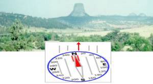
On a hike in Wyoming, you see a strange rock formation off in the distance. Using your compass, you take a bearing to it as shown below:

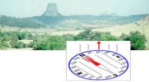
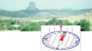
If you turn and face two smaller rock formations farther off in the distance, which of the following bearings would be correct?

1

2
In this case, since you are facing northerly, a turn to the right will be more to the East so #1 is correct.
It is important to keep a feel for general directions in your mind. If it's early morning and the sun is in your face, you are heading east with north on your left and south on your right. Remember, right and left are relative to your current heading. If you're in the northern hemisphere and the sun is at your back, you are heading in some northerly direction. In the southern hemisphere, the sun at your back means you are facing southerly.
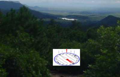
Learning how to use a compass to follow a line of travel is simply pausing to take a reading occasionally while hiking. In the picture below, you're trying to find your way to the lake in the distance to refill your water supply.

Ahead of you, there is no trail and you drop into thick forest. You won't be able to see the lake or easy landmarks for quite awhile.
As you walk, you need to occasionally check your heading on the compass to ensure you are still heading 220 degrees.
You now understand how to use a compass to read your current heading and to take a bearing to a distance landmark. Using a compass in this way will guide you over terrain that you are acquainted with or if you know the general directions you need to travel before hand. But, for new territory, you will also need to know how to read maps and use a compass to guide your way.
 A hiker was hiking along one day when he came to a wide river.
Seeing another hiker on the other bank, he called out, "Hey, how do I get to the other side?" The second hiker looked slowly along the bank to the left, then along the bank to the right, thought a bit, then called back, "You ARE on the other side!" |
| Search Google News for more 'Lost Hiker' news items. |
| 06 Jan 2026 - Log into Facebook |
| 04 Jan 2026 - Phone, dog found as search for missing hiker near Colfax continues, deputies say |
| 06 Jan 2026 - When Devil’s Backbone Trail claimed another young Mt. Baldy adventurer, this is what the world lost |
| 06 Jan 2026 - Search For Missing Bay Area Hiker Ends In Tragedy |
| 23 Dec 2025 - Two lost hikers rescued from frigid Catskill Mountains trail |
| 04 Jan 2026 - Remaining two of three hikers found dead at Mt. Baldy identified |
Comments:
Oct 14, 2015 - jean de amicis
Excellent!
You have to think of it working almost the opposite way from a base plate compass. Instead of putting "red in the shed". Think, you are "putting the shed on top of red". ["put red in the shed " just means aligning the compass needle over the orienting arrow] It's ok if we don't have a red.
Turn until the direction of travel arrow points at your destination. Turn the bezel ring until the 'short luminous line' is above the N arrow.
Think of the 'short luminous line' as being the 'shed'. The N is "red". You're doing the same thing, just kind of the opposite way.
Example: 58˚ azimuth is measured on the map, including adjustment for mag. declination. Turn until 58˚ is below the "fixed index line". Then move the "short luminous line" to above the N by turning the bezel ring. You're all set.
Ask a Question
More Map and Compass Resources at CompassDude.com


Recent Comments