

Dish Pointing
Finding Your Satellite
Adjusting your receiver dish for best reception of a TV signal can be confusing.
Understanding a little about the satellite system and your location on earth will make it much less intimidating.
You will need to understand elevation, azimuth, and skew - weird words, but not too complicated. We'll explain them more farther down the page.
In order to get a clear signal, you need these things:
- a clear path from your receiver to the satellite - no trees or buildings in the way
- the location of the satellite - a degree number provided by your TV carrier, or satellite name
- your location - a latitude/longitude
Instead of trying to figure it all out yourself, try this great tool from Alan first.
Select your satellite name from the list - the leading number is the longitude degree of the satellite.
Replace Chicago, IL with your zipcode or exact address.
Press 'Enter' on your keyboard.
A line will show up on the map indicating the general direction towards the satellite from your location.
The "Location" area will show your latitude and longitude.
The "Dish" area will list your elevation, azimuth, and skew.
Pointing Your Dish
Now that you have your settings, you can set your dish.
Satellites are in geosynchronous orbit over the equator. They are flying around the earth at the same speed the earth rotates, so they stay in a fixed location above the surface. This means the satellite's latitude and longitude remain fixed. You need to aim your dish at this fixed point.
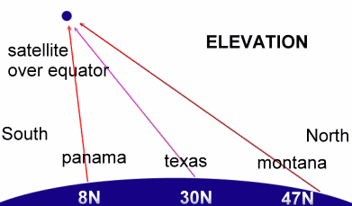 Elevation is the angle up from the ground your dish needs to point.
 Since the satellite is over the equator, the farther from the equator you are (the larger your latitude number), the smaller your angle will be. Your dish will need to point down lower to aim at the satellite.
Imagine the satellite is over the top of South America. Someone in Panama would need to aim their dish nearly straight up while someone in Montana would need to point their dish lower towards the horizon.
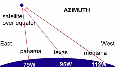 Azimuth is the East to West angle you need to point your dish. This seems to cause the most confusion for people.
 A satellite will have a longitude degree of something like 77.0West. This means the satellite is above the equator at 77.0 degrees west of the 0 degree longitude line, also called the Prime meridian, which runs North-South through England. This satellite would be over the Pacific Ocean just south of Panama.
Someone in Montana would point their dish farther east to aim at this satellite than someone in Panama. Someone in Massachusetts would need to point their dish to the west since they are farther east than the satellite.
You may have two azimuth numbers. One is true and one is magnetic. If you are using a compass to determine your bearing towards the satellite, use the magnetic number because that is using magnetic north for your area - see Declination info for details. Use the true number if you are using a GPS device to determine the direction to the satellite.
Next: Home
 After explaining about latitude, longitude, degrees and minutes, the geography teacher asked, "Suppose I asked you to meet me for lunch at 23 degrees, 4 minutes north latitude and 45 degrees, 15 minutes east longitude?"
After a confused silence, a voice volunteered, "I guess you'd be eating alone." |
| Search Google News for more 'Lost Hiker' news items. |
| 09 Jul 2026 - Lost Hiker on Moat Mountain Trail |
| 09 Jul 2026 - Forest Rangers locate lost hiker in Western Adirondacks |
| 04 Jul 2026 - Site Not Available |
| 06 Jul 2026 - Hiker visiting from Brazil rescued from Mount Washington after getting lost for over 16 hours |
| 09 Jul 2026 - 2 Separate Hikers Rescued On New Hampshire’s Moat Mountain Trail |
| 08 Jul 2026 - Lost Hiker Found in Fulton Chain Wild Forest in Herkimer County |

Comments:
Sep 23, 2016 - Aiodan Colgan
Very informative, thank you.
But, is the USA too far "west" for us in Europe, Ireland in particular, (for us to receive reception from American television broadcasts) ?
Thanks
Aidan
Dec 25, 2018 - PeteBut, is the USA too far "west" for us in Europe, Ireland in particular, (for us to receive reception from American television broadcasts) ?
Thanks
Aidan
Hi there.Thanks for the info.It was very helpful
Aug 25, 2020 - Nisbet SamuelThank you so much .Very informative.
Ask a Question
More Map and Compass Resources at CompassDude.com
Recent Comments