
Triangulation
Triangulation is the process of pinpointing the location of something by taking bearings to it from two remote points.
Forest fire lookout towers used triangulation to locate spot fires.

A ranger at Tower A would see smoke in the distance and take a bearing to it on his compass. This single line was not enough information to locate the fire because it could be anywhere along that line, close or many miles away.
The ranger would radio Tower B and tell him the general direction of the fire. Tower B would then find the fire from his viewpoint and take a bearing. Where the two bearings crossed would pinpoint the fire and firefighters could be efficiently dispatched to put it out.
Sometimes, a third tower would be used to verify the location, but two readings are all that is usually necessary. If a fire occurs directly between two towers or off in a direction that causes their bearings to be similar, then a third bearing is necessary.
This type of triangulation is used by two fixed spots to find a third unknown spot. What you need to do while in the outdoors is similar, but you need to find out where you are, not where something else is.
Finding Yourself
In order to successfully triangulate, known features must exist on your map. In other words, you must have some idea of where you are or be able to identify a well-known landmark from your viewpoint.
By taking bearings to the distant landmarks, you can plot your current location on your map in this way:
- Make sure you have adjusted your compass correctly for declination in this area.
- Orient your map so map north is facing true north.
- Take a bearing to one landmark. Point the direction of travel arrow at it and turn the compass dial until RED is in the Shed.
- Place your compass on the map so that the orienting lines are parallel to the map's north-south meridian lines.
- Move your compass so the top end of one edge of its baseplate ends at the landmark, keeping it aligned with the map's meridians.
- Draw a line along the edge of your compass from the landmark along the bearing you took. You are somewhere on this line.
- Repeat taking a bearing and drawing a line for a second landmark.
- Where these two lines intersect is your approximate location.
Triangulation Example
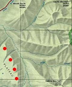 This example will step you through the process of triangulating your location based on bearings to two or more known landmarks.
Look at this section of map - it has mountains, streams, and hills as indicated by the shaded relief enhancements. Notice it does not have contour lines but that doesn't matter when we are just finding directions.
You might find it useful to print the image and actually do these steps.
Print the map and lay it on the floor.
Orient the map for North right where you are and imagine that you can see mountains off in the distance.
You have just climbed the plateau in the southwest, coming up from the southwest. You do not know at which of the 4 red spots you are currently standing, but you can see 3 mountains off in the distance towards the north and east.
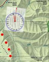
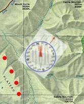
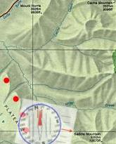
- 16 degrees to Mt. Norris
- 48 degrees to Cache Mountain
- 112 degrees to Saddle Mountain
To simulate taking each of these bearings, turn your compass dial until that bearing is at the index pointer. Then, turn the compass until RED is in the Shed and the direction-of-travel arrow will be pointing along that bearing.
Transfer your bearings to the map and find out where they intersect. If you oriented your map, took correct bearings, and transferred them accurately, your map should look close to:
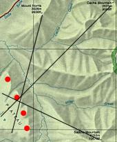
Now you know where you are on the map and in the real world. If you didn't do too good on this one or want to try another, here's another exercise to try.
 Why was longitude boiling mad?
Because it was 360 degrees |
| Search Google News for more 'Lost Hiker' news items. |
| 08 Jan 2026 - Sheriff's Office Recaps Rescue of Lost Hiker in the Bald Hills Last Week |
| 05 Jan 2026 - Placer crews recover body of woman, 40, swept away in American River near Colfax |
| 23 Dec 2025 - Two lost hikers rescued from frigid Catskill Mountains trail |
| 07 Jan 2026 - Overdue Hiker at 7 Falls Found Safe After Nighttime Drone |
| 09 Jan 2026 - Lost hiker saved by search and rescue on Kelowna’s Black Knight Mountain |
| 30 Oct 2025 - Returning to the Appalachian Trail After the Murder That Changed It |
Comments:
Jun 26, 2016 - Carlos Hinojosa
If they're catching fish, I can see with binoculars and they're not likely to move from that position for some time.
Next, I can drive along the beach to get another bearing to triangulate. The only problem is that my iPhone can't see the object because it's so far away.
It is easy to get my coordinates, but how can you accurately get the bearing from my current location to the object? Let's assume you tell me that if I buy some gadget like a scope with a bearing detector, how can I combine both locations and bearings to input the coordinates into my GPS?
Carlos
Thank you for your contributions.
www.videreresearch.com/projects/geolocation-web- application/compass-triangulation
Or, just place your compass's orienting lines as close to that north-south direction as you can estimate. It won't be very accurate, though.
If I'm understanding correctly, you are using the your phone as a compass and align it using its camera, but seem unable to locate the object on the screen, acting as viewfinder, due to insufficient lens magnification, but are able to locate it with your eyes through binoculars.
You must've not realized that nothing prevents you from putting your phone lens in the viewfinder of the binoculars. Binoculars will magnify for the phone just as well as they do for your eyes.
Ask a Question
More Map and Compass Resources at CompassDude.com


Recent Comments