

Latitude and Longitude Coordinates
Every single spot on the earth can be identified by a global latitude and longitude coordinate system - whoa, big words, dude!
Well, let's slow down a bit. Latitude and longitude are just used to pinpoint your location. Translating the earth to a map requires some sort of agreed-upon way to describe each spot.
Take a look at this map:
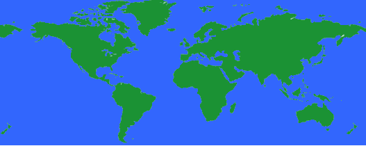
Obviously, that is a map of the earth. You can find the continents and can probably make a good try at pointing to where you live. But, how could you tell someone else where you live so they could quickly find it on their own map? That is where a coordinate system helps.
The Axis
Our coordinate system is going to be based on the spinning earth. The earth spins around on its axis. One end of the axis is the North Pole and the other is the South Pole. These are the two most important points on earth as far as directions and navigating are concerned.
The most important number for figuring out locations is 360. There are 360 degrees in a circle and that is the shape of our world, no matter how you slice it.
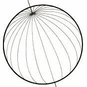
Latitude
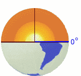
If you could stand at the center of the earth, you could look out at the surface of the earth all around you. With the North Pole directly above your head, if you looked straight ahead in any direction, you would be looking at the equator. This imaginary line is exactly halfway between the north and south poles and has a latitude of 0 degrees because you are looking straight ahead at an angle of 0 degrees. If you look up a bit, maybe at an angle of 30 degrees, you have increased your latitude to 30 degrees North. Continue to look up higher and higher until you are looking straight above you at the north pole which is 90 degrees North.
Maybe this image will help:
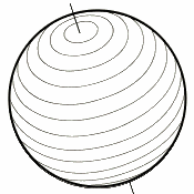
Just like the equator is a line drawn around the earth at 0 degrees latitude, you can draw a line around the earth at any latitude. Draw a lot of these lines and you will see something like this:
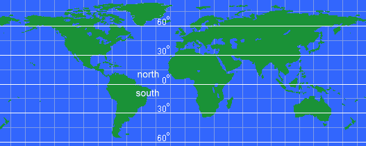
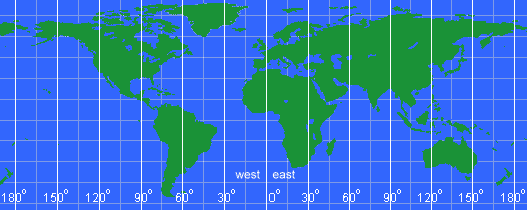
Drawing those latitude lines onto a map would look like this:
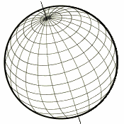
Longitude
Longitude is the angle east or west around the earth, just like latitude is the angle north and south. Longitude lines are called meridians.
For latitudes, we have two fixed points - the north and south poles - that we use as end points. But, going around the earth, there is no start or stop, it just keeps spinning and spinning. So, an arbitrary spot was chosen to be the Start point for longitudes. This spot is the Royal Observatory in Greenwich, UK. The longitude line that runs through it is called the Prime Meridian and is longitude zero degrees.
Notice that longitude lines are not parallel. The closer to the poles you get, the shorter the distance between meridians until they all actually converge at the poles.
Drawing those longitude lines onto a map would look like this:
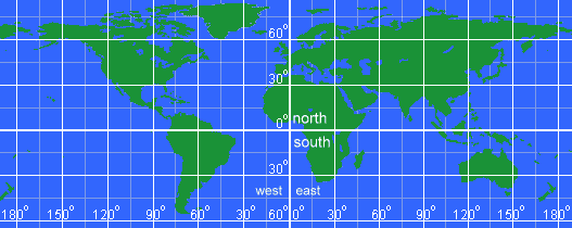
Latitude and Longitude Grid
Combining latitude and longitude results in a grid that covers the globe. Every point can be defined by a north/south degree and an east/west degree.
For example, Seattle, Washington, USA is at latitude 47.6� North and longitude 122.33� West. From the center of the earth, look up 47.6� from the equator and turn right (west) 122.33� from the Prime Meridian and you will be looking directly at Seattle.
And, the complete grid on a map looks like:
Well, degrees are fine and good, but the earth is almost 25000 miles around so dividing that into 360 pieces means each degree is about 69 miles wide around the equator. That isn't very precise. To help with that, each degree is divided into 60 minutes and each minute is divided into 60 seconds. These used to be used all the time, but now fractional degrees are more common.
For example, the location of the White House in Washington, DC is:
| Decimal Degrees | Deg:Min:Sec | |
| Lat: | 38.898648N | 38� 53' 55.133" N |
| Lon: | 77.037692W | 77� 02' 15.691" W |
| Compute Decimal or Degrees/Minutes/Seconds: |
USGS topographic maps are called 7.5 minute maps because they span 7.5 minutes of latitude and 7.5 minutes of longitude. The most common latitude and longitude map is a 1:24,000 scale and the actual map size is about 22 inches by 27 inches. By the way, it takes about 57,000 of these maps to cover the entire US and you can buy any of them you want. Start your collection today! :-)
That's about all there is to latitude and longitude coordinates! Here's some tips to remember:
- Latitude is always given before longitude (49� N 100� E)
- Latitudes are parallel, but longitudes are not
- Degrees West and South are sometimes referred to as negative degrees (-12� -23� is the same as 12 S 23 W)
- A place's latitude effects its climate, but its longitude does not
- Key longitude lines are the Prime Meridian (0�) and the International Date Line (180�)
- Key latitude lines include the equator (0�), tropic of cancer (23� 26' N), tropic of capricorn (23� 26' S), the arctic circle (66� 33' N), and the antarctic circle (66� 33' S)
- Find your location from your latitude/longitude at this page
 Why does WEST longitude have no friends?
Because it is always NEGATIVE. |
| Search Google News for more 'Lost Hiker' news items. |
| 24 Jul 2026 - Experience |
| 20 Jul 2026 - Lost Hiker Mt. Willard |
| 23 Jul 2026 - 83 |
| 23 Jul 2026 - Search continues for missing 77 |
| 22 Jul 2026 - Lost Hiker Rescued at Montaña de Oro State Park in San Luis Obispo |
| 21 Jul 2026 - Hiker Rescued After Getting Lost at Montaña de Oro State Park |

Comments:
Sep 23, 2015 - Jammee
I'm due a check ride next 10 days. I fly a Bell 407GX Helicopter and use a Garmin 1000 all glass cockpit. Heck it's 2015 who plots Lat/long anymore. Well the CHK pilots are now expecting us to plot on an aviation sectional a Lat long for a scene flight just to prove we can do it.
I use to be highly proficient plotting Lat/longs but not anymore. I understand the DDD (N32 W 092 that's too easy, it's the MM & SS pinpoint breakdown that gives me heartache, I don't know why I make it so difficult , any ideas friend? Much appreciate anything you can give me re: plotting Lat/long on Aviation Sectionals
Any links also are appreciated I have not been able to google Lat/long plotting on sectionals, by the way Sectional Scales are 1:500,000
Thank u very much
CB
www.youtube.com/watch?v=uBnY-1F7ayg
Goodluck
thanks
Note: Using both conventions (i.e., -77 dgr W) is incorrect.
If I raise my eyes up 47.6° that would change my latitude to Seattle's. �If I turn my body to my right 122.3� that would change my longitude to Seattle's. �I would be looking directly up at "Seattle"
I am currently going to college after being out of school for sometime;totally changing career paths! I am a GIS seeking student and have fought with this Lat/Long stuff for awhile now. I just wanted to say THANK YOU! reading this TOTALLY helped me to have a complete understanding of just how Lat/Long works! Thank you!!!!! You should be a teacher! 8) I greatly appreciate this sight!I am going to pass this page along to my class mates who are in the same struggle.
Determining Longitude using a straight stick, the sun, and a watch when GPS is not available. Place a straight stick, upright and vertical, in a south facing, horizontal, level, surface. As the sun moves across the sky, mark the end points of the stick's shadow over time while noting the time of each mark. As the sun becomes higher in the sky, the time intervals should be five minutes or less for accurate mapping. Determine which shadow mark and corresponding time is the shortest (the sun is highest in the sky, which is "high noon"). Knowing the time which corresponds with high noon, the time zone your watch is set to, and the fact that the earth rotates 15 degrees every hour or 1/4 degree every minute provides adequate information to determine your longitudinal position using basic math. The watch time must be corrected for accuracy using the Equation of Time.
If you are in the Northern Hemisphere, Latitude can be determined by measuring the angle between the horizon and Polaris, the north star.
Ask a Question
More Map and Compass Resources at CompassDude.com
Recent Comments