Topo Map Skills
A Topographic Map includes contour lines drawn to represent changes in elevation. When you follow a path on a topographic map that crosses these contour lines, you will be either climbing or descending. A path running parallel to contour lines is relatively flat.
When reading a topographic map, you need to visualize in your mind's eye a 3-dimensional view of what the symbols and contour lines are representing.
The most important thing to remember is that CLOSE contour lines mean STEEP terrain and OPEN contour lines mean FLAT terrain.
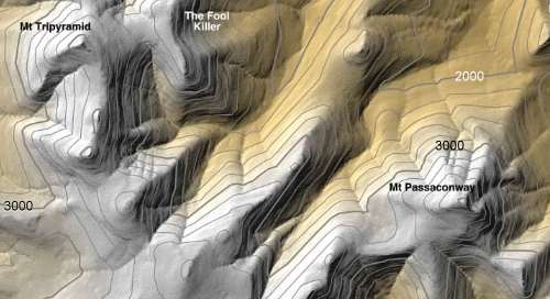
Shaded relief added to a topographic map makes it more realistic and helps visualize the real landscape.
For example, see how the mountains and canyons stand out on this map:

What is the elevation of Mt. Tripyramid? _______________
The closest Index contour line for both peaks is 3,000 feet. You can see another Index line of 2,000 feet. There are 4 Intermediate lines between 2000 and 3000 so each intermediate line represents a 200 foot change in elevation.
Counting up from 3,000 feet, there is 3200, 3400, 3600, 3800, and the top line is 4000 (actually the next index line).
So, both peaks are over 4000 feet and it looks like Mt. Tripyramid is possibly almost 4200 feet high.
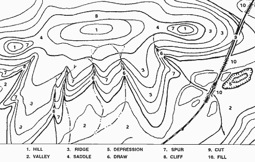
This example of a very simple topographic map shows many common features. Keep your eyes open to see these features on other maps and you will start to understand how a topo map works.

Even without elevation numbers, clues that #1 is a hill include streams converging away from the hilltop, contour lines pointing sharply towards the hilltop (indicating draws), contour lines pointing widely away from the hilltop (indicating rounded ridges).

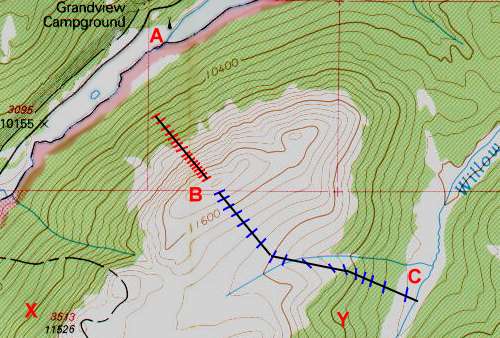
You can also tell the elevation change between each contour line by looking at the Index lines. Notice that the Index line near point B is labeled 11600 feet and the one due north of it is labeled 10400 feet - that is a difference of 1200 feet. Between these two Index lines are two more Index lines so each index line represents a change in 400 feet of elevation - 10400, 10800, 11200, and 11600.
Count the lines between two index lines and you should see there are 4 lines which cause the 400 feet between the two index lines to be divided into 5 intervals, each one being 80 feet in elevation. So, now we know that on this map every contour line represents 80 feet of elevation change.
If you follow a single contour line, your elevation remains constant. For example, starting at point X and following the Index line to the NorthEast, around, and down South to point Y, you would stay at about 10,800 feet.
When you cross contour lines, you are either hiking up or down. Look at the two routes to get to the peak at point B - the red route and the blue route. Each path reaches the top, but the blue route is three times as long as the red route. That means it covers more distance to gain the same elevation so it is a more gradual slope - and probably an easier hike. Going up the red route may require a lot of scrambling and hard work.
Using the map above, pretend you are camped at the Grandview Campground but you heard there is great fishing in Willow Creek at point C over the mountain to the SouthEast. How could you get there?
Well, a straight line to the SouthEast would be shortest on the map, but would include a climb of over 1500 feet!
Instead, heading East from camp and circling the north side of the mountain will result in a longer distance covered but only about 325 feet in elevation! That may be a much better hike.
One other thing to take into consideration. Notice that the ground is colored green up to about the 10,800 foot index line. The white area above that is open ground while the green area is forested. This can be good or bad. The forest can offer shade and coolness, but on the other hand it may be thick and difficult to navigate.
 What do you call a map of the prison system?
A con-tour map! |
| Search Google News for more 'Lost Hiker' news items. |
Comments:
Sep 21, 2015 - Gautam Yadav
Thank you!
Thanks
Ask a Question
More Map and Compass Resources at CompassDude.com


Recent Comments